THE GREAT FLOOD AND THE ARK OF NOAH - 11,500 B.C.
By Jeff Miller, Pittsburgh, Pennsylvania, December 16, 2021
"But such is the irresistible nature of truth, that all it asks, and all it wants, is the liberty of appearing.”
From “The Rights of Man”, by Thomas Paine, 1791
Many or most are familiar with the Biblical story of the Great Flood and the Ark of Noah. All of mankind had become wicked, goes the story, except for Noah, whom God clued in about the impending catastrophe.
It was Noah who was said to have built the ark and survived the great flood, along with “two of every animal”. Noah’s name survived virtually unchanged in such isolated places as Hawaii (Nu-u), the Sudan (Nuh), China (Nu-Wah), the Amazon region (Noa), Phrygia (Noe) and among the Hottentots (Noh) in their respective great flood accounts.
When the Great Flood’s waters receded, the Ark came to rest “in the mountains of Ararat”. Josephus, Eustathius of Antioch, Eusebius, Epiphanius, Chrysostom, Hieronymus, and Theodoritus all identify the Biblical Ararat, where Noah’s ark was said to have come to rest, with Armenia.
Persians refer to the mountain as either Koh-i-nuh, meaning “Mountain of Noah.” Ancient Armenians called it Masis Leusar, meaning “Mountain of the Ark.” Even the form of the name Ararat [in Genesis]…is clearly an Armenian spelling and pronunciation.
After the flood, Ham and his sons went back to their old stomping grounds, namely Egypt. The Sphynx has been dated to 18,000 B.C., well before the flood.
Noah’s son, Ham, father of the Hamitic, or black race, had Cush, Phut, and Mizraim. The empire of Kush to the south of Egypt is known from at least 1970 BC. Mizraim is the name of Upper and Lower Egypt.
Noah’s son Shem has been traditionally held to be the ancestor of the Semitic (or “Shemitic”) people. We know them as the Arabic peoples. Shem’s son, Arpachshad, or Arphaxad, is usually credited founding the Sumerian city of Ur. So Sumeria was, at its genesis, Shemitic. After the flood, Shem headed back to his old stomping grounds, Ur, which has both pre- and post-flood layers, with, as a bonus, the pre-flood layers being the more advance.
Noah’s son Japeth was sire of, among others, Tubal-Cain, Tubal, Cain, Canaan, of the R1b haplogroup “Neanderthal” bloodline of Cain. In the book of Jubilees Japeth was bequeathed the three ‘tongues’ of Europe. Japeth is traditionally seen as the ancestor of Europeans. In fact, Japhetic has been used as a synonym for Caucasians.
“Caucasian”, of course, itself derives from the Caucasus, where Mount Ararat is located.
And so Japeth remained in the Caucasus, and headed for his old stomping grounds of Gobekli Tepe, which, which has both pre- and post-flood layers. As a bonus, the pre-flood layers are more advanced.
The key marker for the “Neanderthalí Line of Cain is the R1b haplogroup. R1b1b mostly likely originated in Western Asia, in north-eastern Anatolia to be precise - exactly where Ararat is located.
Japeth’s son, Gomer, in turn had a son, Ashkeaz. Ashkuz and Ishkuz were names used for the Scythians.
Japeth’s son, Tiras, was associated with the Thracians (research)
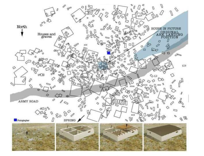
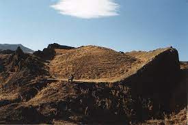
Just after the flood, Noah and the rest of the Ark’s unholy crew founded the first city after the flood, named Naxuan, which means “Noah’s Zion”, or “capitol city of Noah”.
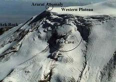
In 1998, 7,000 feet up on the side of Ararat and just above the Durupinar peak, its buildings were first unearthed, along with thousands upon thousands of victims of human sacrifice and cannibalism.
Armenia’s Moses of Chronensis called Naxuan “place of first descent”, the city of Mesha-Naxuan.
In the Epic of Gilgamesh, when he got to Utnapishtim’s (Noah’s) home, Gilgamesh had arrived at the “Mountains of Mashu.” The slope above Naxuan is still called Mashu-r to this day, meaning “resurrection day.”
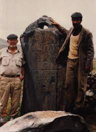
The team that first unearthed Naxuan found a stone altar at Naxuan almost identical in size to one found at Arzep in Turkey:
Azep Altar100%75%50%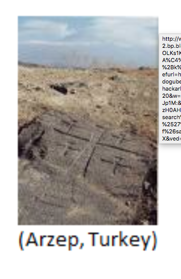
(Altar at Arzep, Turkey)
The altar at Naxuan is a large, unusually square rock, measuring 11 feet in height, 12 feet in width, and 11 feet in length, with and a circumference of 56 feet at the base, as it expanded outward. Add to this a honed out area on top of the altar, ideal for securing a human sacrifice, and channels in the rock connected to it for blood drainage. The visibility and acoustics of the area where it is situated make it ideal for such a hideous ceremony.
I’d show you a picture of this gigantic human sacrifice altar but there are none any longer extant on the web that I can find.
Other than this, not much remains from Naxuan, other than the foundations of its houses and many graves & cemeteries, a virtual “necropolis”. Initially it seems to have been a normal town with surrounding graves. However graves and cemeteries are so abundant they far outnumber the original houses. They are not only found on the outskirts, but all over the place. Literally thousands upon thousands of graves show up in an aerial photograph of Naxuan. The smaller rectangles in the image below are ALL graves:
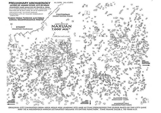 Naxuan100%75%50%
(The Neanderthal-pot-grave-riddled Naxuan, with boat shaped depression just to left of center)
(Naxuan, with boat-shaped depression to right)
Berossus and others describe the pilgrimages to the ark’s resting place in ancient times, pilgrims getting shaved-off souveniers of the ark’s wood, etc. A fake ark of Biblically-correct size would have given pilgrims somewhere to go, and have provided a never-ceasing supply for the continued ceremonies of human sacrifice and cannibalism.
An article that I can no longer locate says “The location feels more like a favorite burial resort of ancient times, and a place of pilgrimage or worship similar to Lourdes.”
“A favorite burial resort of ancient times”, ah, mirth! No, rather, Naxuan was the first post-flood Cainite human sacrifice outpost.
So many graves, a multitude of them. Recall that we’re at a 7,000-foot elevation in what has never been a population center. So where did this multitude come from, when they were still alive?
They were trapped up there by water that was still well up the peak, in an environment where there was nothing to eat.
Recall that the Biblical account, written by the Cainites, has the whole world destroyed, with just Noah and “family” saved. Perhaps that was the simple, fairy-tale version, and the truth was rather more grim.
The Cainites floated comfortably above the fray/flood, sequestered within the ark with their “domestic” human/animal hybrid cows, sheep and pigs, their metallurgy equipment, foodstuffs, et al, and rode out the flood. They eventually descended onto Ararat, whose peaks were still visible above the water.
And those peaks were thronged with thousands of packed-in flood survivors, who’d fled there as the waters rose higher and higher. Whom the Cainites immediately took in thrall with physical force, using iron weapons and terrifying Black Magic human sacrifice rituals. This along with the ability to easily produce fire, which was no mean feat for the non-ark-supported multitude of soaked stone age flood survivors.
And they sacrificed a significant subset of the survivors on the gigantic stone altar, and fed the remaining others - and themselves - on their cannibalized remains. What is there to eat, after all, at 7,000 feet, just post flood?
Eventually, after the flood waters had completely receded, and “normalcy” returned to the world, a fake “tourist ark” was built at Naxuan, right in the middle of the body field. It gave the rubes someplace to visit that wasn’t at a completely-inhospitable 14,000 feet, supported a booming business in “pieces of Noah’s ark”, and kept a flow of human sacrifice victims moving up to this “high place” where sacrifices to Ba’al have ever been performed. The Cainites brought their dark religion with them on the Ark.
Down at the base of Ararat, at the foot of the Ahora Gorge, lay the original village of Arghuri (also spelled Agouri or Ahora). Its name means “where Noah planted the grapevine.” Agouri is built where Noah erected his altar of burnt offering after disembarking from the ark.
After leaving the ark, the most likely route the flood’s survivors would have taken would be down into the Araxes valley. The city of Nakhichevan lies some 60 miles southeast of Ararat, down the Araxes River. In Armenian, nakh means “first”, and chevan means “resting-place”. Pre-Christian author Josephus said “the Armenians call that spot the Landing-place.”
The prehistoric complex at Metsamor lies along the Araxes River to the north northeast of Mount Ararat. It is identified with the city of Aratta in Sumerian epics (3000 B.C.). Neolithic stone circles are located adjacent to site.
The name of the town of Maser, Turkey, 18 miles south of Ararat, means “doomsday.” The name of Kargakonmaz, Turkey, 19 miles south of Ararat, means “the raven will not land”, in reference to the raven of Genesis 8:7. The name of Echmiadzin, Armenia, 32 miles north, means “the descent” or “those who descended.” Tabriz or Ta Baris, Iran is 155 miles from Ararat. It means “the ship”. The use of the definite article in the name indicating a very large and/or famous ship. The nearest body of water is Lake Urmia, a dead salt lake 40 miles to the west, which had and has no ships.
The ancient town of Seron means “place of dispersion.” It is traditionally regarded as where Noah’s sons and their respective families parted.
“Most of these names are no longer used by the Turks who moved into the old villages after their genocide of the Armenians in 1917.” You’ll learn more about the R1b haplogroup Neanderthal’s genocide of the R1a haplogroup Armenians. Without exception, every group persecuted by the Nazi Holocaust was a member of the R1a haplogroup.
The Nazi Holocaust executed in Germany was not religious in nature. It did not persecute “the Jews”. It was racial in nature, and persecuted everyone of the R1a haplogroup.
The heavily-obfuscated Armenian Genocide of the early 20th Century as well as the simultaneous destruction and expulsion of Syriac and Greek Orthodox Christians at that time "enabled the creation of a Turkish ethnonational state.”
I’ll translate that for you. One race was eliminated, so that the other could have the nation to themselves. That’s what “a Turkish ethnonational state” means.
In 1500 B.C., somebody carved this relief of Noah’s Ark resting on top of Mt. Ararat. The location of the carving is not mentioned.
(1500 B.C. stone tablet showing Noah’s Ark stranded on Mount Ararat. A defeated Angel at the mountains foot, with Goliath on top. The carving is primitive, with damage, cracks, and faint, worn inscriptions.)
In 100 B.C., Nicholas identified the mountain of the Ark with the name “Baris” in Armenia. While in 1923, a cartographer from Columbia University identified Baris with Ararat in his Historical Atlas.
Thus, in 100 B.C. Nicholas identified the mountain of the Ark as Mt. Ararat.
In the first half of the third century B.C., a Babylonian priest named Berossus Berossus (Akkadian Bêl-re’ušunu) wrote a Greek history of Babylonia. In direct contradiction of the truth of Noah’s Ark’s actual resting place in Armenia, Berossus’ version of the Babylonian Flood tradition is the ultimate source of the tradition that falsely places the landing place of Noah’s Ark points to Mount Cudi, in what is now Turkey.
In 632 A.D., the Qur’an brazenly and falsely lists Cudi as the location for Noah’s Ark.
Here we have two of the earliest known examples of what is known in the propaganda trade as “disinformation”.
In the 5th Century A.D., Moses Chorenatsi, also known as Moses of Chorene, wrote the most significant mediaeval Armenian history. He tells of Armenian oral traditions containing stories of a flood. The Armenians were what Chorenatsi meant by the “descendants of Aram”. The Armenians told and sang about the Flood and its hero.
Other than Moses of Chorene’s single account, we have no other indigenous written source substantiating Ararat as the resting place of the Ark of Noah, as all pre-Christian books were eradicated by Gregory, founder of the Armenian Church.
It’s a great example of what George Orwell described as the Ministry of Truth, shoving the truth down the Memory Hole, down through history.
In the 7th century A.D., the Etymologiae stated that remains of the Ark were still at Mount Ararat in Armenia.
Hold that in mind as we review this contemporary account from Wikipedia:
“Despite the longstanding association of Armenia with Ararat in Western Christianity, Christians in Armenia did not adopt the idea of Masis as the landing site of the Ark until the arrival of Crusaders in the late 11th century. Thereafter, Armenians adopted the Western identification of Masis as “Mount Ararat,” and relocated the Jacob of Nisibis legend to that peak. The angel’s admonition to Jacob became a new explanation for the pre-Christian taboo against climbing the sacred mountain. Regardless of this cultural impediment, other travelers claimed the summit was physically inaccessible, due to the permanent snow line and an abundance of precipices.”
Wikipedia’s statement “Christians in Armenia did not adopt the idea of Masis as the landing site of the Ark until the arrival of Crusaders in the late 11th century” is false, given that, more than one thousand years previously, in 100 B.C., Nicholas had identified the mountain of the Ark with the name “Baris” in Armenia.
I have exposed the duplicity of Wikipeda by using what was known in the old days as “fact checking”.
The uncredited Intelligence operative from the State propaganda organ known as Wikipedia mentioned “the pre-Christian taboo against climbing the sacred mountain”. Later in this article, when we get to human sacrifice victim-riddled Naxuan, you’ll see why there was a pre-Christian taboo against climbing the sacred mountain.
In 800 A.D., Hayton of Corycus said of Ararat “On the mountain’s summit something black is visible, which people say is the Ark."
Where the snide “people say” is an example of the propaganda technique known as “stonewalling”.
Wikipedia: “Late medieval reports from Ararat often mentioned the survival of Ark fragments, but there was less consensus about whether the vessel itself survived. Petachiah of Regensburg simply declared “the Ark is not there, for it has decayed.”,
Where “not there” and “has decayed” are Mil-speak for “nothing to see, here!”
Wikipedia continues: “Just over a century later, however, Hayton of Corycus claimed that ‘on the mountain’s summit something black is visible, which people say is the Ark."
Where the snide “people say” is an example of the propaganda technique known as “stonewalling”.
You’ll see a picture of the black object on the summit in about three paragraphs. The Ark’s location on the summit is key, as you’ll see further down.
Wikipedia continues: “The first recorded ascent of Ararat was led by Friedrich Parrot in 1829. In his account of the expedition, Parrot wrote that “all the Armenians are firmly persuaded that Noah’s Ark remains to this very day on the top of Ararat, and that, in order to preserve it, no human being is allowed to approach it.”
Later, when we get to human sacrifice victim-riddled Naxuan, you’ll begin to understand why no human being is allowed to approach it.
Wikipedia continues: "James Bryce scaled Ararat in 1876. On his ascent, he discovered a piece of wood about four feet long and five inches thick, evidently cut by some tool, and so far above the limit of trees that it could by no possibility be a natural fragment of one. Bryce cut off a portion of the wood to keep, and later argued that it might plausibly be a remnant of Noah’s ark”.
We’ll now examine the story of John Joseph Nouri. Wikipedia says “John Joseph Nouri claimed to have discovered Noah’s Ark on the summit of Mount Ararat in April 1887.”
You’ll see just how important “on the summit” is further down in my article.
The wikipedia article goes on to say “Little else about him is known for certain.”
Where the general “ittle else about him is known for certain” is an example of the propaganda technique known as “stonewalling”.
The Wikipedia article goes on to say "Born in Baghdad in 1865, Nouri was an archdeacon in the Chaldean Catholic Church. He was a charismatic, well-traveled scholar who spoke multiple languages.
In 1893 Nouri was invited to the Parliament of the World’s Religions in Chicago to speak about his discovery of the Ark. Although the official reports of the event do not say whether such a lecture occurred.”
Where the general “do not say whether such a lecture occurred” is an example of the propaganda technique known as “stonewalling”.
The Wikipedia article goes on to say “Later that year, while visiting San Francisco, Nouri was robbed and left at the Napa Insane Asylum, which took him into custody as a patient.”
Where “took him into custody as a patient” is Mil-speak for “kidnapped and imprisoned by literally blood-drinking generational Satanist Freemasons”.
The Wikipedia article goes on to say “Although he eventually arranged his release, the incident raised questions about his mental state and, therefore, the legitimacy of his extraordinary claims.”
Where the general “questions”, “mental state” and “extraordinary” are all examples of the propaganda technique known as “stonewalling”.
The Wikipedia article goes on to say “Despite being crowned Patriarch at the Chaldean Pontifical Cathedral at Thrissur in 1897, Turkish officials did not corroborate his claim of discovering Noah’s Ark.”
Where the general “Turkish officials” not corroborating John Joseph Nouri’s claim to have discovered Noah’s Ark on the summit of Mt. Ararat is an example of the propaganda technique known as “stonewalling”.
In 1900 and again in 1905, an Armenian named George Hagopian visited the Ark two times.
He took a lie detector test…twice…and passed them both times.
It took Hagopian and his uncle eight days to reach the high grazing areas and glacier of Mt. Ararat from the city of Van. The primary reason to travel to Ararat was a four year drought owing to which sheep were dying in Lake Van area. With a prolonged absence of precipitations the Ark was completely uncovered. They reached it and Hagopian, helped by his uncle, climbed an artificial small staircase up to the roof of Ark.
Hagopian also described the Russia/Turkey border as having a separation where one would go through the Turkey border gate, then walk a little ways, and then go through the Russia border gate.
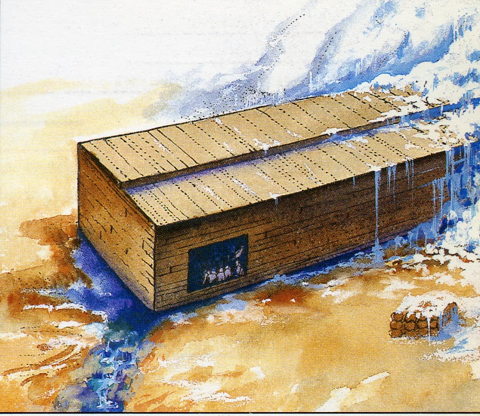
Here’s a drawing that George Hagopian made of what he saw:
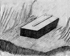
(George Hagopian’s first-person depiction of the Ark of Noah on Mt. Ararat)
Now here’s a photo of the Ark, in situ on Mount Ararat:
(The Ark of Noah, Mount Ararat, Turkey)
Early in the days of the Internet, there was a helicopter flyby video of the Ark. The image immediately above is a still from that video.
Seeing the Ark from this close in 3D makes it incontrovertible, which is why the video was quickly pulled down. I have never been able to locate it again.
A biblicalarcheology.org article which I cannot at this moment locate said “The fact that Hagopian is no longer with us makes it difficult to render any kind of judgement. The story itself is interesting, but it still provides no empirical evidence.”
Where the general “difficult to render any kind of judgement”, “interesting” and “no empirical evidence” are all examples of the propaganda technique known as “stonewalling”.
In 1916, Erna Weist visited the Ark on Mt. Ararat. Erna grew up 150-200 miles north of Mt. Ararat in a German community named Morgentau, Russia, between the Black and Caspian seas.
In 1916, she and everyone at her school heard that the Russians had discovered Noah’s Ark on Mt. Ararat.
Excited by the news, a couple men in Weist’s two families went in a friend’s plane to Ararat and took photographs of Noah’s Ark and then the entire mountain to find possible climbing paths up to the boat.
In 1998, in “Erna’s Medley”, Erna’s daughter, Ruby Paula said “with all the military action taking place, the plane was not noticed, or so they thought, as it flew around the mountain taking pictures of the area that the men thought accessible for climbing, plus close-up pictures of the ark, sticking out an ice glacier.”
In 1916, Erna Weist’s first-person description of the ark as “sticking out of a glacier” is corroborated by George Hagopian’s first-person depiction of the ark.
It is also corroborated by the first-person description by Russian pilot Vladimir Roskovitsky in 2016, where he said “It was grounded on the shore of the lake with about one-fourth of the rear still running out into the water, and its extreme rear was three-fourths under water.”
It is also corroborated by the Tsar’s 1917 expedition, which described “a petrified barge extending from beneath an ice peak”.
It is also corroborated by Dave GuMaer’s 1970 description of a photograph of the ark showing “a large, barge-type craft protruding from the ice. The barge was on a shelf overhanging a frozen lake below. About three-fourths of the structure was still encased in an ice pack. The Ark was tilted at an angle.”
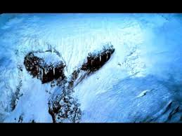
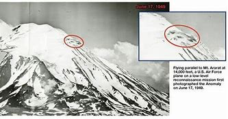
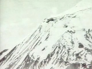
The ark tilted at an angle and sticking out from the ice is also corroborated by this undated photo of “the Ararat anomaly”.
 Noah Ark Anomaly100%75%50%
It is also corroborated by this video still from the 2000’s.
(The Ark of Noah, Mount Ararat, Turkey)
Erna Weist related that the summer of 1916 was extremely hot. That’s why Russian pilot Vladimir Roskovitsky saw the ark “grounded on the shore of a lake, with about one-fourth of the rear still running out into the water, and its extreme rear was three-fourths under water”, versus being frozen in ice as in most years.
Erna was now eight and in grade three at school. Just before school let out for the summer she came home tremendously excited…“They’re saying at school that Noah’s Ark has been seen on Mount Ararat. They say because it is so hot the snow and ice have melted enough to be able to see it. Can we go see the ark Lisa? Can we?”
Then an extraordinary weather phenomenon occurred that made the mountains appear closer than they really were. Early that morning Erna stepped outside and was struck with awe. There appeared on Mount Ararat a tiny black dot about three quarter of the way up. She knew it was Noah’s Ark. Erna, in later years, recalled the dot as being near the center, on a high peak. Since they lived north of Mount Ararat, this would put the ark on the north side of the mountain.
In 1916, Erna Weist’s eyewitness description of Noah’s ark from Morgentau, Russia, about 150 miles from Mt. Ararat as “a tiny black dot about three quarter of the way up, near the center, on a high peak, on the north side of the mountain is corroborated by Hayton of Corycus in 800 A.D., who said of Ararat “On the mountain’s summit something black is visible, which people say is the Ark.”
Erna’s family had a telescope through which the ark could be viewed with greater clarity. “The dark dot became more like a brown square.”
Uncle John was the first to speak. “You know, I think we should go up there. Think you gals could hold out here for a week while we take a closer look?”
Uncle Jacob said “You know, what we need is to hire a plane and zoom down for some close-up pictures.” Henry had friends who had a plane. They would be interested in such a venture.
With all the military action taking place, the plane was not noticed, or so they thought, as it flew around the mountain taking pictures of the area that the men thought accessible for climbing, plus close-up pictures of the ark, sticking out an ice glacier.
With the pictures developed, the family again gathered together with the families of the two men. The pictures were passed around and viewed with fascination. The men decided to climb the mountain and examine the ark. They bought the necessary equipment for the climb and within a few days everything was organized for the expedition.
Shortly after, a group of Bolsheviks on horseback surrounded the house, and seized the climbing equipment, film and negatives at gunpoint, saying “that’s restricted territory, you can’t go there.” The family came under constant surveillance.
Eva Miller Ebeling [1897-1977] was a Russian woman whose husband was Uncle John. She escaped from Russia with her half-sister Katherine Miller Quindt (1895-1970). She was still scared to the day she began talking about the Ark on Ararat that the Soviets would come after her.
Eva worked in the Czar’s palace as a housemaid during World War I when she was about nineteen or twenty years old. Her father was a medical officer in the White Russian Army and a highly respected friend of the Czar and his family. He was the chief medical officer on the expedition that found Noah’s Ark.
Eva "could see Mount Ararat from where she lived…Eva’s father and a 100 men group went on a second expedition to find Noah’s Ark. They did reach the point where they could see the Ark plainly and photos were taken. When he came back from the expedition, he showed my Aunt Eva the photographs and reports.
Then, the Bolsheviks took over and confiscated all of the photographs and reports and killed as many of the men from the expedition as they could find. My aunt Eva was the only one from her family who escaped.
My Aunt, having seen the pictures many times, told me the ark was three decks high, and on top of the roof there was a catwalk that was about knee-high with openings underneath to provide ventilation or light. Another item that Aunt Eva mentioned, her father said that the raised part that looks like a walk way above the roof of the Ark extending the length of it, was about knee high, which the bible said was to be 1 cubit."
This from a July 2000 letter from, Eva’s daughter, Annie VanEaton to Rex Geissler that,
In 1916, Eva Miller’s first-person description “on top of the roof there was a catwalk that was about knee-high with openings underneath to provide ventilation or light” is corroborated by the Tsar’s 1917 mission, which described “a narrow catwalk running down the middle of the top length of the barge”, and “flag catwalk about five feet across down the length of it”.
It is also corroborated by George Hagopian’s later first-hand depiction of the ark.
In 1916, Russian pilot Vladimir Roskovitsky saw the ark “in a remote, obscure canyon of the peak” while flying a plane around Ararat.
“We circled the field several times until we hit the fourteen-thousand-foot mark and then stopped climbing for a few minutes to get used to the altitude. I looked over to the right at that beautiful snow-capped peak, now just a little above us, and for some reason that I can’t explain, turned and headed the plane straight toward it. A couple of circles around the snow-capped dome and then a long, swift glide down the south side and then we suddenly came upon a perfect little gem of a lake, blue as an emerald, but still frozen over on the shady side. We circled around and returned for another look at it. Suddenly my companion whirled around and yelled something and excitedly pointed down at the overflow end of the lake. I looked and nearly fainted!
A submarine! No, it wasn’t, for it had stubby masts, but the top was round over with only a flag catwalk about five feet across down the length of it. What a strange craft, built as though the designer had expected the waves to roll over the top most of the time and had engineered it to wallow in the sea like a log, with those stubby masts carrying only enough sail to keep it facing the waves. (Years later in the Great Lakes I saw the famous “whaleback” ore carriers with the same kind of rounded deck.
We flew down as close as safety permitted and took several circles around it. We were surprised when we got close to it at the immense size of the thing, for it was as long as a city block and would compare very favorably in size to the modern battleships of today. It was grounded on the shore of the lake with about one-fourth of the rear still running out into the water, and its extreme rear was three-fourths under water. It had been partly dismantled on one side near the front, and on the other side there was a great door nearly twenty feet square, but with the door gone. This seemed quite out of proportion, as even today ships seldom have doors even half that large.”
In December 1917, Tsar Nicholas II sent a 150-man expedition to Ararat. Russian officer Alexander A. Koor, who was placed the expedition, described the Ark as measuring 500 feet (150 m) long, 83 feet (25 m) wide, and 50 feet (15 m) high.
Koor stated that the expedition’s report was intercepted by Leon Trotsky, who had the courier shot. Cummings later contacted Koor, who said he had served in the Ararat region in 1915, and heard of the Ark expedition from fellow officers he met in 1921. This was enough to convince Cummings that Koor had not simply plagiarized the New Eden article.[68]: 61–64 An amateur archaeologist, Koor also claimed to have discovered cuneiform inscriptions at Ararat describing the story of the Flood.
Keep those cuneiform inscriptions in mind as we go forward.
In 1917, shortly before the overthrow of the government, the Czar had commissioned some one hundred White Russian soldiers to undertake an investigative trip to Mount Ararat in search of the fabled Ark of Noah that was described in Genesis. This group of soldiers made their trek up the Russian side of Mount Ararat and after much difficulty reached a point on the mountain where the Ark was said to be buried under ice and snow. This was exactly what they found: a petrified barge extending from beneath an ice peak. The Ark of Noah was real and was located on Mount Ararat.
The Tsar’s 1917 mission described “a narrow catwalk running down the middle of the top length of the barge”, and “flag catwalk about five feet across down the length of it”, which corroborates George Hagopian’s later first-hand depiction of the ark.
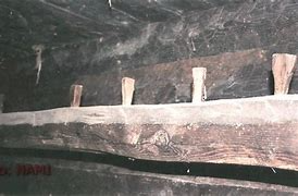
The Tsar’s soldiers had walked inside the structure and had observed animal stalls of all different sizes made of wood. All the wood was petrified. They also found edible wheat and honey. The soldiers chipped away pieces of the petrified wood for later analysis to determine what type of trees were used in its construction.
Armais Arutunoff then continued his story of the expedition. These Russian soldiers were on direct orders from the Czar to measure, photograph and survey everything they found. After this was completed, their samples taken and their sketches carefully catalogued, the soldiers proceeded to leave the sit on Mount Ararat and return with all this important data and immediately report to the Tsar. By the time they returned, the Russian revolution was in full operation. The Russian army was running rampant throughout the country. All but two of the soldiers involved in the Ark expedition were captured, arrested by the Bolsheviks, and then executed.
Of the two that escaped, one was the surveyor and the other soldier was the photographer. The surveyor apparently stayed somewhere in Europe while the photographer made his way to the United States. He would be safer here in America.
Mr. Arutunoff said that some years later he met a Russian soldier, one of the survivors of this expedition, who informed him in great detail of what they had seen, the measurements of the boat, the photographs which had been taken, along with many other facts and details concerning the expedition. This soldier described the surveyors, photographers, artists and scientists who were on the mountain specifically to find the Ark and to prove that it existed on Mount Ararat.
It was some years later that Mr. Arutunoff made the acquaintance of this Russian photographer and was given copies of the Ark pictures. These were the very same photographs Dave GuMaer was shown. Where are the photographs now? After the death of Mr. Artunoff, most of his personal papers have been stored by family members. His immediate family have no recollection of their father ever showing them the two photographs. Why? Was Mr. Arutunoff worried about some possible future problems these photographs might cause his family?
In 1917, Joe Kulik was the water boy on the Russian expedition to Mount Ararat. His grandson, British Columbian Joseph Way, e-mailed a man named B.J. Corbin and told him the story in 1999.
The Russian water boy Kulik stated that he and the Russian Army saw “Noah’s Boat” on the border of Russia and Turkey around 1915-1918.
Joe was born on March 15, 1902, and was ninety-seven years old when he told his story to B.J. Corbin in 1999.
Joe said that, at the beginning of World War I, his family fled Austria and moved to Russia in the Ukraine region. As a fifteen-year-old in 1917, the Russian Army Patrol expedition hired him to feed the horses and the troops while the Russian troops searched for a boat on a mountain. The Russian expedition took him to the Russian border with Turkey where they went up a great mountain. Joe told Geissler that they left the horses behind at one point and went toward the top of the mountain where they saw a huge, long boat with a hole in the side of it. Kulik stated that the boat had moss growing on the top of it. Joe said that nobody took a picture because no one had film at that time. He said that it was like a huge building or three times the size of a small house in width.
Joe’s statements that the Ark had moss growing on it and was resting on the border of Russia and Turkey are both corroborated by George Hagopian’s account.
Joe’s statement that there had been soft or no winters prior to 2016 is also corroborated by both George Hagopian and Erna Weist’s account. Russian pilot Vladimir Roskovitsky’s eyewitness aerial account has the Ark on the edge of an alpine lake, versus frozen in ice, as in later observations, including the most recent joint expedition by the Turkish and the Hong Kong Chinese in 2010.
Around 1939, an issue of the New Eden magazine reported that Russian pilot Vladimir Roskovitsky saw the ark while flying a plane around Ararat in 1916. The story spread like wildfire and was reprinted numerous times in Christian publications. The author of the article was named Floyd Millard Gurley.
Gurley’s neighbor, a retired lawyer and Army officer named Captain Benjamin Franklin Allen claimed that he had heard from other sources about the story of an alleged Russian discovery. Allen’s sources included a relative and a friend who told this same basic story about two men who served in the Czar’s Army during World War I. Allen said these two men had participated in expeditions to Mt. Ararat where the Ark had been sighted by an aviator “in a remote, obscure canyon of the peak.”
Gurley received the basic story from a Russian immigrant widow living in one of his apartments.
Since the propaganda code is universal, the only actual exterior images you’ll find of the ark are tagged “Ararat anomaly”.
Where the general “anomaly” is an example of the propaganda technique known as “stonewalling”.
Here are several of them:
(Noah’s Ark, Mt. Ararat, Turkey)
(Ararat “anomaly”)
(The Ark of Noah on Mt. Ararat)
(The Ark of Noah on Mt. Ararat)
(The Ark of Noah on Mt. Ararat)
Where the general “Ararat anomaly” is an example of the propaganda technique known as “stonewalling”.
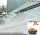
Sometime between 1943 and 1945, a US Air Force Sergeant named Vince Will saw a photograph of the Ark on the cover of “Stars and Stripes” magazine. This according to B.J. Corbin’s “The Explorers of Ararat”, year.
Vince said that the photograph was looking into an opening on the side of the Ark. Vince said “A section of the Ark was sticking out of the snow and ice 40 to 50 feet on a ledge without anything underneath it. The wood was darker than the rocks around it. The wood was pretty good shape. I couldn’t see any holes on the top. There was a hole on the right side where you could see different levels and structural beams. I could see two decks through the hole.”
Here’s a picture that Vince drew of the cover photograph that he saw.
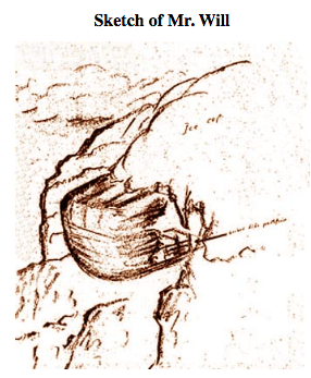
(Vince Will’s drawing of a photograph of the Ark on the cover of Stars and Stripes magazine, sometime between 1943 and 1945.)
It is nearly identical to this video still from a flyby in the 2000’s.
(The Ark of Noah, Mount Ararat, Turkey, 2000s)
In May, 1948, heavy rains on Mount Ararat combined with three earthquakes exposed this formation at Durupinar from the surrounding mud in May 1948:
(The fake “Tourist Ark”, constructed sometime during the “dark ages”, which was found lower down on Mt. Ararat in 1948)
In a remarkable display of foot dragging, the site was not surveyed until twelve years later, in 1960. The expedition members “found only soil and rocks”. Their official news release concluded that “there were no visible archaeological remains” and that this formation “was a freak of nature and not man-made”.
In 1970, a wealthy Armenian from Bartlesville, Oklahoma named Armais Arutunoff stated to Dave GuMaer that, in his youth, he lived in Erivan (now Yerevan, Armenia) at the time the men from the Czar’s expedition returned from their investigation of the ark.
Arutunoff vividly recalled hearing the men’s excited story in the streets of Erivan, of how they had climbed the mountain twenty-five miles away, had entered the great ship, and verified the aviator’s report. The sketch of a photo given to Arutunoff in Don Shockey’s book “The Painful Mountain” showed three Russians standing in an open doorway of the ark.
From what Dave GuMaer could remember from Arutunoff’s description, the dimensions of the Ark were some 450 feet long, by fifty feet high, by some 100 to 150 feet wide. It was in the shape of a barge.
Not a ship, a barge.
In 1970, Armais Arutunoff showed Dave GuMaer two photographs of Noah’s Ark, taken by a photographer from the Tsar’s expedition of 1917.
Dave remembers them as being grainy and enlarged but clearly showing the barge Arutunoff had just described. The pictures were of a large, barge-type craft protruding from the ice. The barge was on a shelf overhanging a frozen lake below. About three-fourths of the structure was still encased in an ice pack. The Ark was tilted at an angle.
(Dave GuMaer’s sketch of the photo that Armais Arutunoff showed him in 1970)
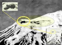
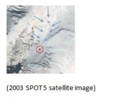
In the early 1970’s, an American named Edward E. Crawford was in the midst of in-depth study of the ancient text of Genesis in its original Hebrew tongue. In 1973, during a summer of extreme ice melt at Ararat’s summit, an American named Edward E. Crawford was studying a Landsat image of Mt. Ararat. He found what appeared to be a rectilinear manmade structure protruding from the ice.
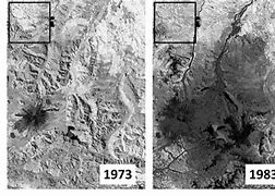
(Landsat images showing the “Ararat anomaly”, 1973, 1983)
Underscoring the depth of the conspiracy to obscure the find, it would be 17 years before Crawford would be granted permits and visit the site.
From 1960 to 1977, the fake tourist Ark at Durupinar was completely ignored.
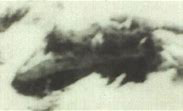
In 1973, the CIA took this photo of “the Ararat anomaly”.
(1973 CIA photo of the “Ararat anomaly”)
In 1977, the fake tourist Ark at Durupinar was “rediscovered” and promoted by self-styled archaeologist and amateur explorer Ron Wyatt. Throughout the 1980s Wyatt repeatedly tried to interest other people in the site, to no avail.
Not far from the mountain, two and 14 miles from Ararat, respectively, were found groupings of very heavy so-called “drogue stones” or anchor stones. They are much larger than their known counterparts from the Mediterranean (see photos below for scale).
(Anchor stone from the Ark of Noah, 14 miles from Mt. Ararat)
They’re the anchor stones of which Joseph F. Dumond bizarrely said “They have no anchor stones although they could claim the ones in Kazan”. As if the anchor stones would work on the Durupinar “ark” and not on the one higher up on the mountain.
But the propagandist knows that many or most readers will grasp virtually any straw, no matter how thin, to remain off the hook of personal responsibility.
Here’s a depiction of them in action:
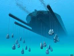
(Artist’s depiction of anchor stones on the Ark of Noah - note fraudulent boat shape, vs. correct rectangular shape)
Well aware of Wyatt’s Durupinar research, Crawford pressed on studying the object he’d discovered far above in 1973. National Geographic is not well-known as a publication which might support the Genesis account of a boat capsized on a mountaintop nowhere near any sign of a river at an elevation of 4500 meters (14764 feet). Indeed, the popular magazine made no mention of the 1983 discovery of what is now known as the “Ahora Covenant Inscription”.
That omission is an example of the propaganda technique known as “stonewalling”.
The discovery was first published in the Field Notes section of the quarterly “Research & Exploration: A Scholarly Publication of the National Geographic Society”, 10(4), Autumn, 1994, p. 484.
The article is entitled “Proto-Sumerian Inscriptions in the Ahora Gorge of Büyük Agri (Greater Mt Ararat), Turkey” and authored by Edward E. Crawford, director of Project von Bora. Of what would seem to be of monumental importance, the article concluded:
"In 1983, ten years after examining that Landsat photo, Crawford found this writing high in the inhospitable and nearly inaccessible Ahora Gorge:
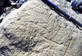
(Ahora Gorge Inscription - photo by Brian Bartlet)
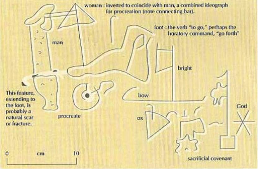
(Ahora Gorge Inscription, translation)
Thus, reading from right to left, as was common, the inscription appears to read, "“God’s sacrificial covenant of the bright bow is to go forth and procreate.”
Irrespective of anyone’s interpretation, the inscription indicates a fully developed proto-Sumerian writing system, found high in the inhospitable and nearly inaccessible Ahora Gorge of Büyük Agri, or “Mount Ararat”. Furthermore, these ideograms appear more representational, in that they are less stylized than proto-Sumerian found to the south and in Mesopotamia, which suggests that they are significantly older. Also, the irregular size and manner in which the individual pictographs are arranged in relation to each other, when compared to other proto-Sumerian writing, is consistent with the suggestion that this Ahora Covenant Inscription is older.
There was never any follow-up as this proved to be the last hard-copy issue of the scholarly publication. This may be rather disturbing because, although now recognized by prominent archaeologists, it could well be the case that the oldest known sample of human writing has largely gone unnoticed.
The inscription says: “(Because of) the divine mystery (revealed) of the savour of the sacrifice accepted, the sacrifice of wild ox, ram, lamb, [and possibly bird], (there is the sacrificial covenant of) the rainbow, let man and woman go forth, procreate, and be fruitful, or have progeny.” Turkeyís Senior Sumerologist, Veysel Donbaz, confirmed the translation.
Where “and possibly bird” is an example of the propaganda technique known as “stonewalling”, obscuring the human-bird hybrid god worshipped by the Neanderthal for over one hundred thousand years.
So, it’s 1983, and we’ve got Crawford with a snow-free satellite photo of the ark’s location and a proto-Sumerian inscription on Ararat corroborating it.
Crawford’s 1983 discovery of the pre-Mesopotamian Ahora Gorge inscription corroborates Russian officer Alexander A. Koor’s first-hand description of cuneiform inscriptions describing the story of the Flood at the resting place of the Ark on the summit in 1917.
In 1985, right after Edward E. Crawford rocked the world with his Ahora Gorge covenant inscription, Ron Wyatt was joined by David Fasold in an expedition recounted in Fasold’s “The Ark of Noah”. As soon as Fasold saw the site, he exclaimed that it was a shipwreck.
Then state-of-the-art ground-penetrating radar equipment and a frequency generator yielded a regular internal structure as documented in a report to the Turkish government. Here’s a picture of it:
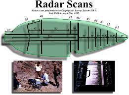
(ground-penetrating radar scan of the fake tourist Ark at Durupinar)
The fake tourist Ark is, incorrectly, boat-shaped, while Noah’s ark in Hagopian’s drawing and photographs is, correctly, rectangular/barge shaped.
The length of the formation 538†ft (164†m), very close to the 300 cubits (157 m, 515†ft) of the Noah’s Ark in the Bible. Fasold believed the team found the fossilized remains of the upper deck and that the original reed substructure had disappeared.
I think that Ron Wyatt and David Fasold were disinformation-spewing Intelligence assets.
I think that Crawford’s clear-as-day 1973 Landsat image got everybody scared, and the “controlled opposition” leak of the fake tourist ark, promulgated as the real thing, was put forward to keep the rubes from heading up to the top of the Ahora gorge, where George Hagopian, and the Russians before him, had walked around on the Ark, and had gone inside it.
The majority of the eyewitness sightings of the ark, and the Ahora Gorge inscription are on the Northeast side of the mountain. As are all of the photos in this article, labeled “Ararat anomaly”.
In 1999, Joe Kulik, a water boy on the 1917 Tsar’s expedition to the ark, described “a huge, long boat with a hole in the side of it.”
This is corroborated by Russian pilot Vladimir Roskovitsky’s first hand aerial view of from 1916, when he described "a great door nearly twenty feet square, but with the door gone. This seemed quite out of proportion, as even today ships seldom have doors even half that large.”
It is also corroborated by the Armenian Armais Arutunoff showing Dave GuMaer a photograph of the ark with a doorway in the side which “appeared to be about twenty-five feet high and some twenty-five or thirty feet wide” in 1970.
In December 1999, Crawford gave a status report on the find in Ankara, Turkey. He was able to show SAF Major General Philip Nuber, ret. and USAF Major General Robert Boots, ODC, how he knew that the ancient structure, which had emerged out of the ice surface in the melt of 1973, had again emerged above the surface in 1998. Because of the re-emergence of the ancient structure above the surface of the receding ice during the melt of 1998, the confirmation of his discovery was no longer classified.
Both Generals Nuber and Boots advised and assisted Crawford in his correspondence to General Edip Baser and the Turkish General Staff, informing the Turkish Military of the confirmation of this discovery. General Boots also called upon Crawford to give the same report that had been given to him and General Nuber to the Chief of Station at the U.S. Embassy in Ankara before leaving Turkey.
It should be noted that Major General Nuber was in charge of military mapping and satellite imaging at the time of Crawford’s first announcement of the discovery of the structure. If it was anyone’s job in the world to know and to be able to corroborate this discovery, it was Major General Nuber’s, and he did.
In 2000 Crawford uncovered an IKONOS Satellite image that confirmed the 1973 Landsat photo. I don’t have a copy of it, and can’t locate one at this writing.
In late 2008 Crawford openly reported on a very significant 2003 SPOT 5 satellite photo. The photo revealed that Turkish F-16 fighters had dropped a 500-pound bomb just off the northeast end of the structure, leaving a 60-meter wide crater.
The shock wave from the blast apparently travelled the entire length of the hollow structure. Genesis mentions that the Ark had a window near the very top. Eyewitnesses, including Hagopian, had previously confirmed that this window runs the entire length of both sides of the structure. The blast blew large chunks of ice from the windows atop the Ark. These ice chunks can be seen in the photo as they are brighter than the glaciers they landed upon.
The photo has been scrubbed from the web. Here’s a screen-shot copy of it from an old e-mail of mine:
(Screen shot from Project Von Bora)
The Project Von Bora website said “the 2003 SPOT 5 photo had previously been suppressed by Turkish red tape.”
Where “red tape” is Mil-speak for “Great Big Conspiracy”.
The 2003 SPOT 5 satellite photo again confirmed the object’s location and orientation. The coordinates are 39∞43’3.51"N, 44∞17’36.29"E, elevation 4498 meters - the exact same location as the 1973 Landsat photo.
I think that the pilot deliberately “just missed”.
The blasts served to more clearly outline the perimeter of the Ark. I’m guessing that the force of the blasts shifted the great structure enough that it cracked the hard ice that had previously encased most of it.
Remarkably IKONOS refused to sell the full-sized version of this photo to Crawford. Remarkable, in that they are in the business of selling enlarged satellite photos.
Here’s a model based on the SPOT5 satellite image, also from the Project Von Bora website:
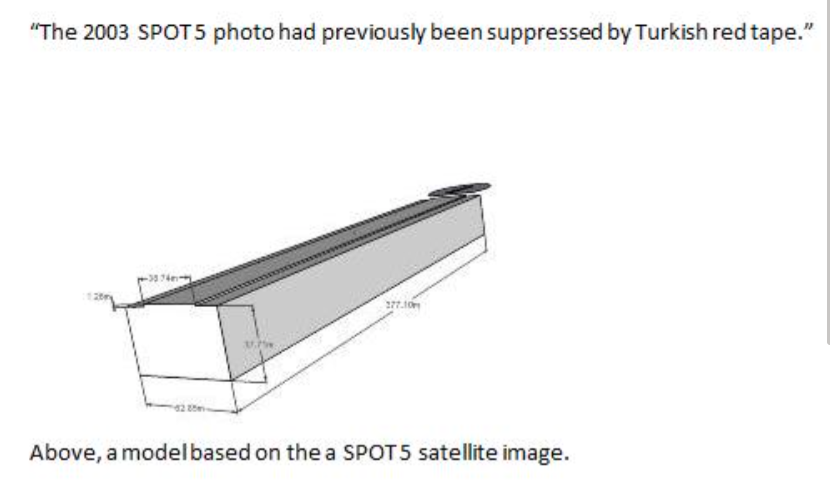
(Model based on the SPOT 5 satellite image)
This image of the tilting ark is corroborated by Dave GuMaer’s 1970 description of a photograph of the ark as “The Ark was tilted at an angle.”
25 years after his Landsat discovery, Crawford created a website called Project Von Bora. Its shell still exists, but most of its content is gone. Fortunately, I saved a few photos and a good bit of copy from it, which is integrated into this article.
This is copy from the website: “Project von Bora was founded over 25 years ago as a result of Edward E. Crawford undertaking an in-depth study of the ancient text contained in the biblical book of Genesis in it’s original Hebrew tongue. This led him to discover a directive beckoning him to the mountains of the high Anatolian plateau in the Southwestern portion of the continent of Asia. Today his work is continued true to form and foundation by his hand-picked team of researchers, scientists, linguists, and sumerologists, and many generous contributors. Project von Bora exists to protect, preserve, and make known these ancient writings and their various corporeal counterparts which are not only of great scholarly importance, but shine true as living words of paramount significance to life and mankind…"Project von Bora… . “The proof of the entire matter is the fact that the ancient ark is at the designated site.”
On 1990, 17 years after he first saw the anomaly in the Landsat photo, Crawford’s team was finally able to obtain the required permits and visit the site in the Landsat photo. On 28 August, 1990, they found two parallel crevasses corresponding with the two sides of the object in the Landsat photo. One of the crevasses was venting a rush of expanding air into the morning sunlight, suggesting a large underlying hollow structure very close to the ice surface. Crawford also identified two very long and perfectly straight hewn beams just under the surface.
Here’s a photo of it from the now memory-holed website “Project Von Bora”:
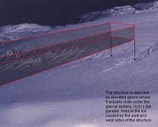
(Outline of Noah’s ark on Ararat, from Edward E. Crawford’s now memory-holed website “Project Von Bora”)
In 1997, making things even more interesting, Fasold declared under oath in a court of law that the claim that the Durupinar site represented Noah’s ark was "absolute BS”.
Fasold’s late-in-life conversion was probably rather that of an agent with changed orders from his superiors.
In regard to Fasold, it is hard to imagine that one could or would flip back and forth between feeling that the ribbed, superstructured, ship-shaped object either was or was not a ship. I’m guessing he was an intelligence asset who was charged with Machiavellianly first agreeing with, and then later pulling the rug out from under/disagreeing with Wyatt, who was the “good cop” in the Confidence game.
Under this thesis, upon Wyatt’s beating of the drums for Durupinar as the actual Ark of Noah, asset/stooge Fasold was dispatched as a Trojan Horse to first agree with, then disagree with/take down Wyatt. As evidence mounts for the Ark higher up on the mountain, the Cainites were forced to fall back to calling the fake ark the real thing, despite the, er, uncomfortable questions that grave-riddled Naxuan presents. Neither Naxuan nor the Durupinar site have been excavated or investigated, to date.
Within five miles of the ark, in front of a very ancient stone house, Wyatt found two grave markers that bore the eight-cross symbols of Noah and his family. This above an ancient, petroglyphic portrayal of Noah’s death on one marker and his wife’s on the other. Here’s a photo of them:
(The graves of Noah and his wife)
The grave markers were subsequently vandalized and the house destroyed. The graves were exhumed by grave robbers, with over one hundred million U.S. dollars worth of gold and gemstones were stolen from the graves. Noah’s wife’s grave produced a bodice covered with large precious stones - it sold on the Turkish black market for around $75 million.
Enormous human bones appeared in some of the hotels in the area soon after the graves were robbed. The size of the bones suggests that the Antediluvians were between 12-15 feet tall. One of the burial crypts was later recovered and is in a back room of a museum in Ankara, Turkey. It is 18 feet long. Og, son of Anak travelled on the ark and was the only one of the giants permitted to survive the Flood.
The authorities are aware of the identity of the most probable person responsible for this outrage, a man involved in Ark searches in the past. He dropped from the public eye shortly after the theft from Noah’s and his wife’s graves.
“The Turkish authorities are seeking to recover these precious artifacts and to punish the thieves.”
Later, as Crawford’s investigation gained steam, the folks in charge would be forced into supporting the fake, tourist ark at the Durupinar site as the actual ark, to at all costs keep attention off the real one sitting where it always had, up at the top of the Ahora gorge.
A year later, in 1998, yet another team found ancient stone foundations of buildings, along with a host of human remains, 7,000 feet up on the side of Ararat and just above the Durupinar peak. The site is believed to be Naxuan, the first settlement after the flood. The name Naxuan means “Noah’s Zion”, or “capitol city of Noah”.
Armenia’s Moses of Chronensis called it the “place of first descent”, the city of Mesha-Naxuan. In the Epic of Gilgamesh, when he got to Utnapishtim’s (Noah’s) home, Gilgamesh had arrived at the “Mountains of Mashu.” The slope above Naxuan is still called Mashu-r to this day, meaning “resurrection day.”
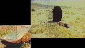
Just below Naxuan, directly down the hill from it, we have the Durupinar site. It looks like a boat, has ribs like a boat, metal fittings were found, etc.
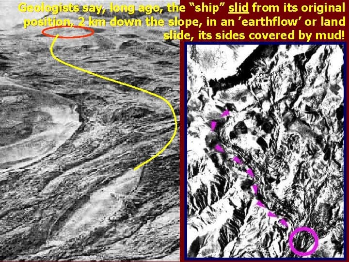
At some point, the fake tourist ark is theorized to have slid down the slope on a lava flow from its original resting place from the boat-shaped depression higher up on the slope at body-riddled Naxuan. Here’s a picture of it from a “What To Think” disinformation website:
(The Durupinar site, foreground, with previously described original ark impression and Naxuan in top left corner, circled in red)
The Turkish government has a plaque at Durupinar claiming it is Noah’s Ark.
On Joseph F. Dumond’s sightedmoon.com, he says “On the other hand those who would say that Noah’s Ark is still to be found on Mount Ararat have produced the following evidence.
-
They have no boat or boat shaped object at all
-
They have no anchor stones although they could claim the ones in Kazan
-
They can not satisfied the many location names as recorded in history by many different authors as we have in this News Letter. In fact not one historical myth mentions Mount Ararat as the place of the landing. Again it was the Mountains of Urartu, the hary urartu.
-
They do have individuals who claim to have seen it on Mount Ararat. But not one has been substantiated by another witness or reliable source.
-
Again zip, nada, nothing to prove their case at all. No hard facts, just emotional statements.
(Joseph F. Dumond - can you see how the image is off-center to the left, to focus attention on Joseph’s left eye? That’s because, to generational Satanist Freemasons like Mr. Dumond, the left eye is the “eye of Will” or “the eye of Horus”.)
Can you see how Joe says “They do have individuals who claim to have seen it on Mount Ararat. But not one has been substantiated by another witness or reliable source.” He’s generalized “George Hagopian” down to an “”individual”, a single “unreliable” source. That’s disinformation artistry for you, straight up.
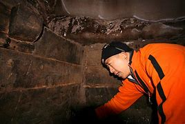
Most unfortunately for the Turkish government, Mr. Dumond, and the rest of the literal army of propagandists trying to suppress the truth of the matter, in 2007, a joint Turkish and Hong Kong expedition set out to scale Mount Ararat, in search for new evidence of the Ark.
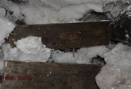
In 2010, Chinese and Turkish explorers found the remnants of a vessel high up on Mount Ararat, and recovered wooden specimens from an altitude of 13,000 feet. They went right up to where George Hagopian said the Ark was, right to the coordinates of the “Ararat anomaly”, walked right in, and took a bunch of pictures.
If you’d like some easy proof that there is, wait for it, a Great Big Conspiracy, fire up Google and type in the words Noah’s Ark, no quotes. You won’t see any of the photos that follow. Now type in the words Noah’s Ark Interior, no quotes. You won’t see any of the photos that follow.
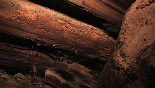
(Noah’s ark, interior, Mt. Ararat, 2010)
(Noah’s ark, interior, Mt. Ararat, 2010)
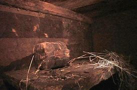
(Noah’s ark, interior, Mt. Ararat, 2010)
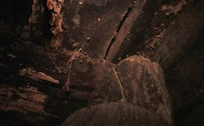
(Noah’s ark, interior, Mt. Ararat, 2010)
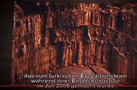
(Noah’s ark, interior, Mt. Ararat, 2010)
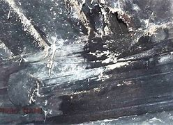
(Noah’s ark, interior, Mt. Ararat, 2010)
(Noah’s ark, interior, Mt. Ararat, 2010)
(Noah’s ark, interior, Mt. Ararat, 2010)
(Noah’s ark, interior, Mt. Ararat, 2010)
(Noah’s ark, interior, Mt. Ararat, 2010)
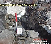
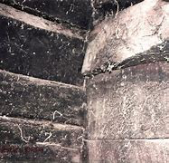
(Cave entrance just below Noah’s Ark)
The expedition found a total of seven spaces with beams, doors, hooks, stairs, rope, crystal, and hay. It ís significant to note that Babylonian flood hero Atrahasis ark had seven decks.
“This is all reported to be a fake.”
- Randall Price, Director of Judaic Studies, Liberty University, 2015
In the quote immediately above, the general “this is all reported to be fake” is an example of the propaganda technique known as “stonewalling”.
In October, 2015, Brian Thomas, Ph.D. said “According to personal correspondence with other serious Ark searchers, investigations of the 2010 NAMI claims concluded that they were fake. The searchers described it as a movie-set on a mountainside location that matched none of the eyewitness Ark accounts. Someone hauled huge wooden structures up the mountain during the offseason (non-summertime), and set them into a glacial crevasse. The steep-sided mountain is in constant motion as the weight of the glaciers, with freeze-thaw cycles, heave and move rocks and ice. Avalanches are quite common, too. So it didn’t take long for the planted structure to look well-settled-in.”
Where the general “other serious Ark searchers” is an example of the propaganda technique known as “stonewalling”.
Which other serious Ark searchers, specifically, please? What investigations, and when, precisely, please?
The propagandist knows that many or most readers will grasp virtually any straw, no matter how thin, to remain off the hook of personal responsibility.